Manzanita Lake

Manzanita Lake is the largest lake in Mount Lassen Volcanic National Park.  It has a large campground, lots of day use areas and best of all . . . it has the possibility of getting some really good shots of Mount Lassen reflecting on the lake. 

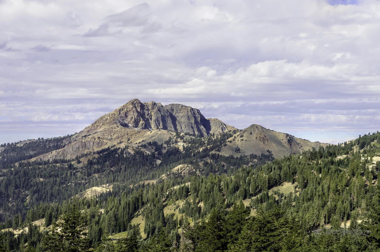
There are very few times that I leave the house with a specific image in mind and then smile when I see it on my computer screen.  This is just about a perfect match.  That is Mount Lassen on the right and part of Chaos Crags on the left.  The lake was really that blue!  I had a big smile on my face!

There is a one mile plus a bit trail around Manzanita Lake.  To get to the shore where you can see Mount Lassen requires that you hike a little over half way around.  We stopped along the way, of course.

The campgrounds were full and the picnic areas were bustling.  There were kayaks and canoes out on the lake and overall the feeling was one of fun and relaxation.

There are lots of logs just hanging out along the shore.

Some oldtrees are still standing!

And some old logs have been left on the shore. 

I ventured out into some marshy grass for this one.  The mosquitoes were out in force!

Even though I had not spotted Mount Lassen I was very much enjoying this hike.  You would enjoy it as well.  Pretty easy walk.

Ya just gotta love that golden light.

Tom arrived on the 'scene' before me.  I could spot him ahead of me on the shore and I knew he had arrived because he was no longer moving.  AHA!  I did not have much further to walk.

We watched this guy fish for quite a bit.  We could see his line glittering as he threw it out onto the water.  Catching that glitter was another matter.

Green, green, the world was green!

After getting some good photographs of the mountains and lake we rounded a corner on our way back.  This group was getting ready to dive and Tom caught the action.  The water was very cold and when they surfaced they were screaming!  Tom got the whole series and has sent them the photos. 

That's all folks.  Thanks for walking along with us.

Lassen By Road

Just driving through Lassen, with lots of stops at legal turnouts, is a trip worth taking.  No long hikes needed, although a few select meadows can easily be explored.  Enjoy our ride.

This is my favorite of the photos I took.

Just after you enter Lassen Volcanic National Park you get to cross a bridge with steam vents (fumaroles) rising on both sides.  A smell of spoiled eggs (hydrogen sulfide gas) greets you!  The small area is named Sulfur Works, at one time a mine built by Mathias Supan in 1865. For twenty years sulfur was extracted from the area and used in a variety of 'mine medicines'.  At one time, the Supan family built a bathhouse built over one of the steam vents, overnight cabins and even a dining hall!

These are so close to the rail that you could reach in . . . Not recommended.  There are endless opportunities to use these mud pots and create abstract images.

The white and orange ground crusts are sulfates.  They evaporate from the water and their color intensity is related to how moist the area is.

What amazes me is how close vegetation can grow so close to active hydro-thermal areas.

Yet, I wonder if this tree is going to make it.

Further up the road.

Mount Lassen in the background.

Emerald Lake is home to the Cascade Frog, Rama cascadae.  Trout that were introduced at one time almost eradicated the frog and now the trout are being removed in hopes that the frog will have a fighting chance to escape extinction.  The Cascade Frog lives in wetlands from near sea level to high mountains and is considered a 'Species of Special Concern in California'.  This is the highest elevation that they have been found.  It is thought that the frog was transported to the lake by being stuck on the foot of a migrating waterfowl.

Emerald Lake was named for its emerald-green water which is caused by the abundant green algae that grows on the bottom of its warm and shallow lake bottom.  Deeper and colder glacial lakes do not support such abundant algae growth and thus appear more blue.  We drove by Emerald Lake numerous times and found its color to be highly dependent on light.

Just up the road from Emerald Lake is Lake Helen.  This lake is glacier fed and a shimmering dark blue.  This photos was taken while on our hike to Bumpass Hell.

We enjoyed our lunch at a picnic table at Helen Lake.  This happy creature joined us.

Our view from the picnic table.

There was one pull out where we stopped several times.  We both tried panos.  It is just so difficult to properly show the expansiveness of the park.If you look really carefully you might spot Lake Alamar in the upper right.

There were several meadows along the road.  This one, in particular, caused us to pull over.  I would imagine that in the spring this whole area may well be under water.  As it is now, much of the what appears to be a grassy area is actually a bog!

As drove up a pretty steep road we looked over and then pulled over.  This is the meadow we photographed that you see above.

This is called a puzzle rock.  It was sitting in an interpretive road pull out in the area that was devastated just about a hundred years ago by an explosive eruption by Mount Lassen that sent huge 3 ton rocks up to three miles away from the eruption site.  These rocks were too hot to touch for days and when some of them cooled off they split into many pieces.  The theory is that you could take these pieces and reconstruct them into the large rock.  The most significant thing for me was how nature has recovered this area and what we see now are tall trees surrounding these large rocks.

Taken from the Devastated Area pull out showing the north side of Mount Lassen.  This was the side that erupted.

Tom loved the detail on this sign.  Hat Lake is listed as 'intermittent'.  I suspect that means that sometimes it is a lake and sometimes a 'bog'.  On this day it was a bog with an interesting creek.

Path to some privacy!

Where the stream goes under the road.  On the other side, a small waterfall as it empties into a new stream bed.

The small waterfall looked interesting enough but all I had was my Nikon Df with my 55mm macro lens.  I was surprised to find it as not too shabby, even handheld!

We left our camp site in Mineral and knowing we left more than enough photos to warrant a return trip.  We had not checked out Manzanita Lake, but we would do that another day.  We left a few photos for our friends.  They are behind every curve, every meadow, every pull-out and along the hike to Bumpass Hell.  We hope you go and pick them up.

Hell

Specifically, Bumpass Hell!!  With a name like, that the photographer in me puts the destination as my day one priority as Tom and I set out to photograph in Lassen Volcanic National Park.  This park has taken its place in my top 5 parks and the photographs from this one hike will go a long way in explaining why.

The mud pots, boiling cauldrons and hissing steam vents are testimony to our planet's continued cycle of creation and destruction.  This area, Bumpass Hell, was our destination.  There are several locations in Lassen Volcanic National Park that exhibit hydro-thermal activity.  Bumpass Hell is the largest location.

But, you gotta make some effort to get to Hell!  We pulled out at every opportunity.  Every curve in the road (and there are many) brought on new delights, wondrous awe and a deep sense of gratitude for being able to just be present in such a place.

The clouds were moving rapidly.  As the clouds lifted the sky just got more intensely blue.  Lassen Volcanic is known for its clear night skies.  We were fortunate that there was little haze and no wildfires in the area.

The flowers were abundant.  Some mountain sides are a bright yellow with dark pine trees.

Cropped photo from above to show detail in the rock.

I believe this is Mount Conard.  It, along with Mount Brokeoff, Mount Dillard and Pilot Pinnacle, mark the remnant edge of what, 400,000 years ago, was a huge volcano.  That ancient mountian was about 11 miles across and towered 11.500 fee…

I believe this is Mount Conard.  It, along with Mount Brokeoff, Mount Dillard and Pilot Pinnacle, mark the remnant edge of what, 400,000 years ago, was a huge volcano.  That ancient mountian was about 11 miles across and towered 11.500 feet in height.

An off-item to find at a pull-out on our way to Bumpass Hell.  It is part of 'Earth Scope', a network of 875 stations along the western US whose purpose is to trace and study the movement of the earth's crust.  It uses satellites from the Global Positioning System to keep track of this antenna's position.  Movement as small as 1/8 of an inch is detectable.

When we finally arrived at the Bumpass Hell Trailhead we were delighted to see only one other car in the parking lot!  By the time we returned to our car there were many more cars but still lots of parking available.  This photo was taken from the trail.  The trail is listed as 1.8 miles to Hell, a short distance!  The trail has a slow upward incline until the last little bit.  It is rocky but relatively easy to navigate.  The views from any turn of the trail are breathtaking.  I would have been happy with my photographic opportunities for the day even without making it to our desired final destination.

Our last view, across this lovely valley, of our ride home.  And we were just starting!

This rock formation is seen on the south face of Mt. Lassen.  There are still some patches of snow at the top.

Not looking up now!  Straight ahead view of that interesting rock.

As we hiked we saw many interesting trees.  We photographed something about every 15 feet.  No wonder it took us so long to walk 1.8 miles!  Not once did we get out of breath or break into a sweat!

Not all the path was this level or clear of rocks.  Besides, the lupine was with us the whole way.  I have never seen so many lupine.

Looking south across a valley.  That bright green in the foreground is manzanita!  It is dwarf sized ground cover. 

I continually had to remind myself that I was not going to photograph any more trees, no matter how interesting.  My goal was ahead of me and continually stopping was delaying my progress!

I am totally undisciplined!

Hopeless!

Lupine along our path.

That looks so unusual it might appear as a fake green.  But, it is young lupine!  I was told that lupine is not often seen in the park.  This year, with the extra snow and the early bloom and then an early decline of another flower (sorry, I forgot which one), the lupine have had a rare chance to bloom along the path to Bumpass Hell.

Lupine as far as you can see.

Can you spot the lupine?  WOW

By now we have been passed on the trail by many.  We are beginning to see people returning!  We are asking, "How much further?"  We were told that when the path begins to go down we were getting close.  Good!!

By now we have been passed on the trail by many.  We are beginning to see people returning!  We are asking, "How much further?"  We were told that when the path begins to go down we were getting close.  Good!!

We rounded yet another corner and there it was.  The tip on the trail going down was nice but not necessary.  We could smell this bad egg a long way off.  There are signs everywhere about the need to stay on the trail and not to leave the boardwalk.  Bumpass Hell is the largest concentration of hydro-thermal features in the park.  It and the others are all connected to the same geo-thermal molten system.

Chaos is hell!

The black scum is pyrite, an iron sulfide mineral that is sometimes known as 'Fool's Gold'.  Iron leaches from rocks deep below combine with sulfur as it rises through the hydrothermal system and become pyrite.

When the wind changes direction this lookout clears out quickly!

As we started our hike back to our car I was happy to see these right along the path not far from Hell.

So where did this name come from?  Kendall Bumpass (November 6, 1809–1885) was a miner, mountaineer and guide.  One day while giving a tour of the this area to some dignitaries he accidentally stepped into a scalding mud bank or pot hole.  He burned one leg so badly that it had to be amputated.  His life's ambition of turning this area into a tourist destination was dashed.