Rio Grande at Del Norte

After viewing the birthplace of the Rio Grande, overlooking the Weminuche Wilderness, we were excited to be parked right by the banks of the river when we spent one night in Del Norte.  After getting Mellie all set up we walked the edge of the river.  It looked like it was 'plenty full' and large logs were moving quickly downstream.

This gentleman showed up and cast his line (fly fishing).  He was a friendly guy and offered up that he was a stock photographer, edited a fishing magazine and was camped with his Casita (a small RV) just a few spots from us.  He was fishing for large brown trout.  He said it was too early still to catch them as they preferred to eat along the shore but did not like to be seen so they would wait until just before dark to start biting.  He also said the Rio Grande was quite 'full' and would crest about 2 am in the morning.  He did not think the flooding would be enough to reach the RVs.

Pleasant walk home.

The next morning we could see evidence where the Rio Grande had crested during the night.  Not too much, but interesting to see the change.

Tom started taking SLOOOOW shots.
South Fork

It is a short trip from Pagosa Springs to South Fork going over Wolf Creek Pass.  South Fork is a small community with no traffic lights, McDonald's or Taco Bell.  It does have a gas station, a liquor store and a very nice general store.  When I write 'general' I mean it!  It has all the basic needs of hikers, bikers, fishermen, campers, RVers, and cooks.

Nice place to stay but too close to the highway for me.

South Fork is on the southern end of Highway 149.  We had been told that this very scenic highway was not recommended for RVs.  By parking Mellie in South Fork we were within driving distance of Creede and Lake City.

Creede sits just below a deep canyon that at one time had numerous mining camps.  Today it is the only incorporated city in Mineral County, CO.  In 2010 the census listed its population at 201.  It is charming and colorful. There are some artist galleries and an active theater company.

On the corner of Wall and Main Streets . . .

Creede is like many old mining towns that are continually re-inventing themselves as tourist and artist destinations.

Can you spot Tom?

Slim pickings for new and interesting flowers in Creede.

Walking around Creede, peeking into windows (most stores were closed when we arrived), and watching people is fun but not nearly enough adventure for us.  We decided to try the Bachelor's Loop, a self-guided 17 mile dirt road that would stop at 8 different historical mining sites.  We started up the road which ran parallel to Willow Creek.  It seems like all creeks in this area of Colorado are moving with unusual force and lots of water from spring snow melting.  All was going well until Ms Prissy Prius started sliding backwards and not holding any traction to the road!!  It occurred to me that my car and its occupants could slide all the way backwards and down into the creek!  Tom hopped out to guide me driving backwards, very, very slowly . . . . excruciatingly slowly to a lower part of the road.  Just as we got to a wider part of the road a huge black powerful pickup zipped right past us and up the hill.  Relieved, we found our way back into town.  It was getting towards evening by then so we returned to South Fork.

The beginning of Bachelor's Loop.  Looks pretty tame at this point!

We saw numerous retaining walls built.  Our guess is that these steep walls just keep 'coming down' in this narrow canyon.  They did not look that secure to me!

These were supports for train tracks at one time.

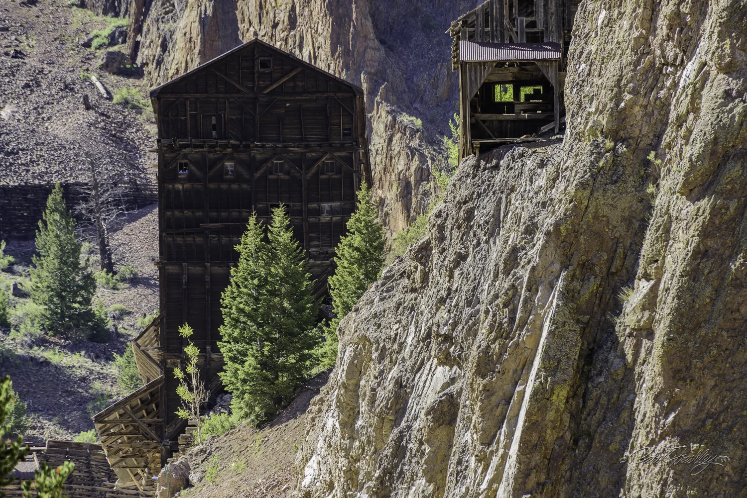
Amazing wood structures!  I was hoping for an interpretive sign in the area but never found one. 

More retaining walls.  It seemed to me that the wall was built progressively higher to protect the wood structure below it.

Just around the corner the road goes steeply upward!  It was up that part of the road that we backed down.

The next morning we decided to drive to Lake City.  Highway 149 goes right through Creede, up over Spring Creek Pass and then over Slumgullion Pass.  My daughter informed me that the Slumgullion Pass has nothing to do with Slumgullion Stew.  We agreed this road is not for Mellie.  Until you get close to Slumgullion Pass the road is not too bad and we spotted lots of RV parks along the way.  This country is just gorgeous, breathtaking, expansive and very tough to capture the grandeur.  One surprise was North Clear Creek Falls.  Wow!

Along the road.

Numerous properties along the road are for sale.  How about a 10 cabin fixer upper?

A picture is worth a thousand words.

This is North Clear Creek Falls.  Would you like it slow?

Or would you like it fast?

Or, maybe just the top?

Or from further downstream as a black and white?

Or with a fisheye's view?

From the car.

From the car.

From the car.

As you enter Lake City you drive right by the Lake Fork of the Gunnison River.

We drove through Lake City and decided it would be on a short list of places to visit from our Gunnison camp.  We dined at the Altitude Restaurant (very, very nice) and returned quickly to South Fork.  The next day we took off about midday for Natural Arch.  That was another adventure.  We started off missing an obvious turn and getting lost before doubling back.  Then we opted for longer route thinking the county road might be smoother.  Wrong!  We stopped along the way because no matter which way we went the scenery was just spectacular at every turn.  I rode the high side of deep ruts in the road, constantly checked to make sure we still had cell phone contact and kept wondering where the signs were for this well known landmark.  We were rewarded when we got to the site.

We were trying to find the right county road and came across an area that I think was just outside Del Norte.  Every house in the community was different.  Several of them had this type of variegated roof.

Where are we?  Hmmm 112 or CR 38 or hmmmmm . . . pretty mountains!

We see these ranch entrances all over the place.  They are massive.  I think this ranch is at the top of the food chain!

A two image pano.

There was a trail, of sorts, that looked like it led to the top.  What a great view might be had from up there.  This was taken about half way up.

Not a bad view from very near the top.  The rocks were getting to be too much for this climber.

I wisely decided to head back down.  Where is Ann when I need her help in getting up the last 10 feet?  I got down by sliding on my fanny!

After shooting all we wanted at Natural Arch we headed back to South Fork.  The vistas were awesome.  The rutted road seemed to matter less and less.

Since 1895!!

A flower for Kati.  Hope she is healing quickly so she can get back to shooting her camera.  I miss her photos and know the rest of you do as well.

That is all of South Fork.  Tonight we are in Del Norte.  Even smaller than South Fork but we had an awesome pizza and salad at the Three Barrel Brewery.  If you drive through here you should definitely stop and eat there.  Thanks for joining us.

Pagosa Springs

Our first stop in Pagosa Springs was at the Visitor's Center.  We were given some excellent information and once we got Mellie all set up we decided to head for Treasure Falls, the number one item on the list and just 15 miles northeast on Highway 160.  You can see part of the waterfall from the parking area.  The hike is just a quarter mile, but quite steep.  We took advantage of the benches along the way, read the interpretive signs on the trail and walked slowly while photographing flowers.

From the parking lot.

We are in training mode on waterfalls!  Not too many around AZ to get some good experience under your photo belt.  Here the waterfalls are more common and at this time of year, with snow melt, they are thundering down canyons.  Treasure Falls is located between two narrow ridges and the light is not bright.  Tom and I discussed later that our efforts to get a 'fast' shot failed.  That is too bad since this fall is best captured, we believe, as a forceful and fast waterfall.  The image above is not slow enough nor fast enough!  I decided to post it anyway because it may give you a sense of the place.

This image of Treasure Falls was taken with a 10 step ND filter and a shutter speed of 13 seconds.  The filter can, and did in this image, leave a nasty color cast.  After working with it in post for longer than I can normally stand, I decided it would make a perfect black and white image.

I thought of Kati as I got down on my belly to photograph the bottoms of these flowers.

We still had time to drive up to Wolf Creek Pass and see how road would be for Mellie as we continued on to South Fork.  It would be fine!  No sharp switchbacks (well, maybe one).  The lanes were wide and there were pullouts to allow faster drivers to pass us.  On the way we spotted one pullout that looked interesting.  We thought the site had good sunrise potential so we returned the next morning just as the sun was coming up over the eastern edge of the valley.

This outlook gives one a sense of the valley below.  There are some major rock outcroppings that allow you to 'peer through'.

That is Treasure Falls from the pullout.

A morning shot.  It might have been as good as we anticipated had it not been so hazy.

A typical scene on the way to Treasure Falls.  This is the land of green, wide open spaces with log fences and snow caps on distant mountains.  It first it felt like we needed to de-saturate the greens!!  They were just too bright!  Oh, to be a desert dweller in a green land!!!

We thought we had enough time left to explore one more spot.  We underestimated the time we would need!!  Surprised?  Surely you are not.  It takes a lot longer when you keep stopping to capture wonderful shots.  Besides, it was a dirt road and you know how I drive Ms. Prissy Prius on such roads.  The road we chose was CR 326 at the Blanco Basin Turnoff.  We did not complete the full 40 mile round trip drive.  I will go back through the whole road in the future.

Hmmmm . . . "Tom, did you desaturate the green in this image?!  "I may have."

This road was in excellent condition for about half of the distance we drove.  Along the way were numerous ranches, all nicely fenced and cared for.

Finally, a bit o'gold color showing up.

I had been driving while Tom shot from the car or hopped out to get a shot.  These curvy county roads require concentration and stopping along the side of the road is not always possible as there are no pullouts.  Fortunately, there is little traffic so if you can be seen by an approaching car they are good about going around you.  But, this possible image capture pulled me to the side to shoot.  They were on my side of the car and I gladly took my turn.

The next day we decided to try the drive to Williams Creek. This drive starts on Piedra Road (CR 600) which after about 22 miles becomes FS 631.  There is another turn on FS 640 to reach the Williams Creek Reservoir.  On the return we went back to FS 631 and turned right towards the Weminuche Wilderness.

This is the Williams Creek Reservoir.  It was very cold and very windy.  Rain threatened!  Me?  I stayed in the car and sent Tom out to get the best he could.  Hats off to him as he worked the possibilities for about 45 minutes, sometimes in the rain!!!

They gave up as it started to rain.  Tom did not!  He got more than his lens wet!

Rain and cows in the distance.

Just the smallest amount of light gives one the idea of what some good light would offer this scene.

There must be a song for these drives.  Something like 'Down a County Road . . . "

The weather was a factor on this day.  For most of the day we had threatening rain, heavy clouds with bits of sunshine here and there.  As soon as Tom got a shot set up the brief, momentary bit of light would be gone.

When we reached the end of FS 631 we came upon a huge semi with a flat bed trailer. There were guys just standing around and with a bit of inquiry we found out that they had delivered a HUGE piece of equipment to the farm down below in the valley.  We could hear the shovel working away.  As we finished up our shooting (about an hour) and headed back down the road we saw that they had loaded the shovel onto the truck.  My first thought was to get in front of them or I would be stuck on a narrow county road going even slower than my usual 15 mph.  Oh, so not correct!!  I had barely driven 5 miles and I could hear this truck barreling down the road behind me.  This truck was speeding!!!!  I quickly picked up my pace and saw a bit more distance between us but still had to keep up my speed.  Only later did I realize that I should have found a wide spot in the road and let him pass me.  Oh, wide spot?  Not easy to find.  And, we would have been chewing his dust for days.  Finally, we managed to pull off a side road and slightly up a hill.  Tom jumped out to try and get a 'safe' head-on shot of what I now thought was a BEAST!  We then followed him at a safe and relatively dust free distance until we got into town.

Look at that dust trail!!  He was hauling *ss!!

I end this post with two personal images.  First is Tom in his usual stance as he looks at a possible shot.  I just so love this guy!  I stay with the car as he steps out.  I monitor oncoming traffic and make sure we are both safe.  Second, a photo of our home, Mellie.  The most common question we get is, "Where are you?"  On this day we were parked next to the Blanca River about 9 miles south of Pagosa Springs.

Thanks for sharing our adventures.