Burney Falls

We heard, "You just gotta go to Burney Falls!  You just GOTTA go to Burney Falls!" So, we went to Burney Falls.  President Teddy Roosevelt described Burney Falls as the 8th Wonder of the World.  It was declared a National Landmark in December of 1954.  The falls are part of a state park located in the Cascade Range.

This is your first view of Burney Falls.  Turns out it is not even the best view, by far.  You can hear the roar of the waterfall as soon as you open your car door.  Just 150 feet later you see this image.  WOW!

There is a viewpoint at the top looking down and across the waterfall.  Maybe that should state waterfall(S).  My challenge was the incredible dynamic range as the right side of the waterfall was already in bright sunlight while the left side was almost dark in shade.  I tried a partial ND with and without a polarizing filter (tricky).  It is easy to get the sky all wompy-wacko when you use both.

Finally, the combination of filters gave me a fighting chance for some post editing to make it all look right.  The waterfall is listed at 129 feet in height and more than 100 million gallons of water a day fall over the rocks or seep through!  The water comes from underground springs that surface a short distance upstream from the falls.  The area is composed of a lot of porous basalt which retains rainwater and snow melt in an underground reservoir.  This waterfall is not affected much by seasonal changes in water availability.

Tom gave up on shooting the whole scene.  The dynamic range was just too much and he did not want to fool with filters.  Sometimes the fall back idea that problems can be fixed in post just does not hold up.  He quickly moved to shooting detail shots.  After post processing we realized that each of us had settled on a very different white balance.  The scene, as he saw it was much cooler than I remember it.  So, as not to jar your brain by interspersing the difference, I have chosen to put mine on together followed by his images.  There is no right or wrong white balance.

So, here you have the secret . . . Barney Falls is really hundreds of waterfalls all rolled into one!  Each of these baby waterfalls is seeping through basalt.  The water is not just trickling down from the two large waterfalls.  This phenomenon is photographic ecstasy as you can stand for hours looking for interesting compositions, textures, colors, and more.

I, personally, loved the strings of water seeping through the basalt rock that can be captured before they hit the rocks.

Just so you know in advance . . . a warning . . . finding these spots of mini waterfalls can become addictive.  We would give up lunch to find another composition that was just right.

OK, it is Tom's turn.  In addition to the change in white balance you will immediately see how different his 'style' is from mine.  It is so much fun to look at his images as he gives them to me to post.  He surely sees the world with different eyes.

Thanks for joining us.
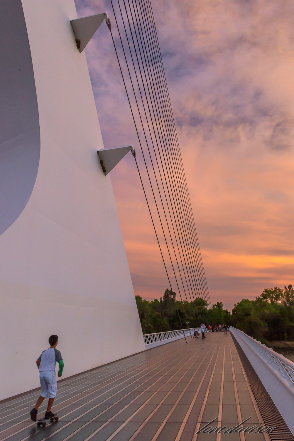
Sundial Bridge

One of the key attractions in in Redding, CA is the Sundial Bridge. It links the north and south campuses of the Turtle Bay Exploration Park.  Designed by Spanish architect, Santiago Calatrava, it appears to suspend weightlessly over the Sacramento River without ever touching the water below.

The bridge is a popular local attraction.

The tall pylon is 217 feet high and supports 4,300 feet of cable.

Tom can twist and turn in fascinating ways to capture an image!!

I began to think of this structure as less of a means to suspend and more as a harp for God's angels.  They come at midnight and play . . .

The pylon is a working sundial, but only between 11 and 3.  If the sky is clear you can actually trace the shadow of its large arc.  The shadow moves about a foot a minute!!

The whole structure really stands out in a good colorful sunset.  (Doesn't everything?)

The deck is composed of 200 tons of glass and granite.  While you cannot see through the glass to the water below, the light that is transmitted through the deck makes it appear weightless.

The deck is composed of 200 tons of glass and granite.  While you cannot see through the glass to the water below, the light that is transmitted through the deck makes it appear weightless.

At nights, the lights below the deck give the bridge an other-worldly appearance. 

Blue hour.

Move an inch on the deck and the whole view changes.

The sun must be over the hill.

Lassen By Road

Just driving through Lassen, with lots of stops at legal turnouts, is a trip worth taking.  No long hikes needed, although a few select meadows can easily be explored.  Enjoy our ride.

This is my favorite of the photos I took.

Just after you enter Lassen Volcanic National Park you get to cross a bridge with steam vents (fumaroles) rising on both sides.  A smell of spoiled eggs (hydrogen sulfide gas) greets you!  The small area is named Sulfur Works, at one time a mine built by Mathias Supan in 1865. For twenty years sulfur was extracted from the area and used in a variety of 'mine medicines'.  At one time, the Supan family built a bathhouse built over one of the steam vents, overnight cabins and even a dining hall!

These are so close to the rail that you could reach in . . . Not recommended.  There are endless opportunities to use these mud pots and create abstract images.

The white and orange ground crusts are sulfates.  They evaporate from the water and their color intensity is related to how moist the area is.

What amazes me is how close vegetation can grow so close to active hydro-thermal areas.

Yet, I wonder if this tree is going to make it.

Further up the road.

Mount Lassen in the background.

Emerald Lake is home to the Cascade Frog, Rama cascadae.  Trout that were introduced at one time almost eradicated the frog and now the trout are being removed in hopes that the frog will have a fighting chance to escape extinction.  The Cascade Frog lives in wetlands from near sea level to high mountains and is considered a 'Species of Special Concern in California'.  This is the highest elevation that they have been found.  It is thought that the frog was transported to the lake by being stuck on the foot of a migrating waterfowl.

Emerald Lake was named for its emerald-green water which is caused by the abundant green algae that grows on the bottom of its warm and shallow lake bottom.  Deeper and colder glacial lakes do not support such abundant algae growth and thus appear more blue.  We drove by Emerald Lake numerous times and found its color to be highly dependent on light.

Just up the road from Emerald Lake is Lake Helen.  This lake is glacier fed and a shimmering dark blue.  This photos was taken while on our hike to Bumpass Hell.

We enjoyed our lunch at a picnic table at Helen Lake.  This happy creature joined us.

Our view from the picnic table.

There was one pull out where we stopped several times.  We both tried panos.  It is just so difficult to properly show the expansiveness of the park.If you look really carefully you might spot Lake Alamar in the upper right.

There were several meadows along the road.  This one, in particular, caused us to pull over.  I would imagine that in the spring this whole area may well be under water.  As it is now, much of the what appears to be a grassy area is actually a bog!

As drove up a pretty steep road we looked over and then pulled over.  This is the meadow we photographed that you see above.

This is called a puzzle rock.  It was sitting in an interpretive road pull out in the area that was devastated just about a hundred years ago by an explosive eruption by Mount Lassen that sent huge 3 ton rocks up to three miles away from the eruption site.  These rocks were too hot to touch for days and when some of them cooled off they split into many pieces.  The theory is that you could take these pieces and reconstruct them into the large rock.  The most significant thing for me was how nature has recovered this area and what we see now are tall trees surrounding these large rocks.

Taken from the Devastated Area pull out showing the north side of Mount Lassen.  This was the side that erupted.

Tom loved the detail on this sign.  Hat Lake is listed as 'intermittent'.  I suspect that means that sometimes it is a lake and sometimes a 'bog'.  On this day it was a bog with an interesting creek.

Path to some privacy!

Where the stream goes under the road.  On the other side, a small waterfall as it empties into a new stream bed.

The small waterfall looked interesting enough but all I had was my Nikon Df with my 55mm macro lens.  I was surprised to find it as not too shabby, even handheld!

We left our camp site in Mineral and knowing we left more than enough photos to warrant a return trip.  We had not checked out Manzanita Lake, but we would do that another day.  We left a few photos for our friends.  They are behind every curve, every meadow, every pull-out and along the hike to Bumpass Hell.  We hope you go and pick them up.